


NDDV-LaPeyrouse

raymondfn
User
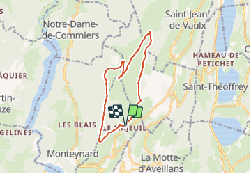

Length
12.6 km

Max alt
1707 m

Uphill gradient
763 m
Km-Effort
23 km

Min alt
970 m

Downhill gradient
760 m
Boucle
Yes
Creation date :
2021-09-07 13:10:41.858
Updated on :
2021-09-07 13:18:38.31
4h50
Difficulty : Very difficult

FREE GPS app for hiking
 SityTrail
IGN / Geographical institutes
SityTrail Plus
The world is yours!
About
Trail Walking of 12.6 km to be discovered at Auvergne-Rhône-Alpes, Isère, La Motte-Saint-Martin. This trail is proposed by raymondfn.
Positioning
Country:
France
Region :
Auvergne-Rhône-Alpes
Department/Province :
Isère
Municipality :
La Motte-Saint-Martin
Location:
Unknown
Start:(Dec)
Start:(UTM)
715086 ; 4983796 (31T) N.
Comments